


Virtual Community Meeting #2
Couldn’t attend our second virtual meeting? No problem! Take our second community survey to see what was discussed and share your thoughts and ideas.
Scroll down to the Get Involved section to download the presentation and watch the recording.

The Cicero Avenue Corridor Study is a multi-disciplinary effort to investigate potential transportation and land use policy improvements to put forth redevelopment alternatives for the Cicero Avenue corridor from Interstate-55 to Marquette Road/67th Street. This regionally significant corridor serves as a gateway to the City of Chicago for visitors arriving at Midway Airport; is a key commercial anchor for Garfield Ridge, Clearing, Archer Heights, West Elsdon, and West Lawn; and is one of the top ten truck routes in Cook County, facilitating freight movement in the region.
To develop a unified vision for the corridor, the City of Chicago’s Department of Transportation (CDOT) and Department of Planning and Development (DPD) are partnering with a range of local stakeholder to:
Address the needs of all users of the corridor;
Evaluate street design and real estate market demand; and,
Create an enduring plan for revitalization that improves vibrancy, livability, functionality, and safety in the community.
Planning Process:
The corridor study kicked-off at the end of 2020, and with community stakeholder input, will conclude with the publication of a corridor plan that will include the following elements:
A community engagement process to develop a shared vision for the corridor with local stakeholders.
The evaluation of existing transportation infrastructure, roadway safety, land uses, and real estate market.
The creation of site development scenarios, building design guidelines, and corridor design alternatives.
A strategy for implementation of improvements, cost estimates and potential funding sources.
The development of a Stakeholder Resource Reference Guide that includes tools and City resources to promote corridor revitalization.


Thank you to all who attended our second Virtual Community Meeting on Tuesday, May 24, 2022 hosted by the Chicago Department of Transportation (CDOT), in partnership with the Department of Planning and Development (DPD). At the meeting, the project team presented key findings, preliminary transportation and land use concepts, and urban design ideas for the corridor. This study includes the evaluation of street design, land use, and development along Cicero Avenue, between the Stevenson expressway (I-55) and Marquette Road. The study seeks to put forth a recommended revitalization plan for the corridor.
Missed the meeting and want to be a part of our planning process:
Download the presentation and watch the recording from the second Virtual Community Meeting!
Take our second community survey to share your thoughts and ideas.
Our first Virtual Community Meeting was held on Tuesday June 29, 2021, download the presentation and watch the recording to see what was discussed!
The Cicero Avenue Corridor Study’s planning process includes multiple opportunities for community engagement. Project updates and opportunities for community members to participate in the planning process will be announced through this website and other media communications, like social media. Another community meeting is being planned for the fall, more details to follow. Sign up below to receive direct updates for the project.
For any additional questions or comments please reach out through the contact section.
Sign up below!

The Cicero Avenue Corridor Study team compiled frequently asked questions to help give a better understanding of the project. For any additional questions please reach out through the contact section. As more questions are posed and the project progresses, this section will be updated.
how was this portion of cicero avenue chosen?
This portion of Cicero Avenue is an important neighborhood thoroughfare, regional freight route, and connection to Midway Airport, which prior to the Covid-19 pandemic served 22 million passengers a year, as well as a link to the rest of the City and the Loop. Historically the focus of the corridor has been on accommodating traffic volume and speeds rather than balancing the needs of all roadway users. The physical conditions of the roadway and adjacent land development patterns present challenges such as heavy traffic volumes, safety, and difficult pedestrian crossings. Through the study, the City will build upon identified community priorities to develop an implementation and phasing plan for future improvements.
how can I get involved and provide feedback?
Please visit the Get Involved tab for more information about all opportunities to provide input.
Bilingual opportunities will be provided throughout the planning process to share your feedback. You can sign up to receive project updates by completing the form above and navigate to the Spanish version of the website in the tab above.
what will be included in the corridor study?
Based on an existing conditions analysis and robust community engagement, the study will provide transportation, land use, retail market and design recommendations to revitalize and improve the functionality and livability of the corridor. The study will include an analysis of existing conditions and a set of recommendations as follows:
Existing Conditions Analysis will include:
Previous Plans and Studies
Land Use
Market Analysis
Traffic Study / Crash Analysis
Transportation Infrastructure
Pedestrian – sidewalks, crossings, ADA
Vehicular – roadway safety, capacity, circulation
Opportunities for Bicycle Infrastructure
Transit Connections
Final Recommendations will include:
Site Development Scenarios
Land Use Recommendations
Building Design Guidelines
Corridor Design Alternatives
Roadway Improvements - geometry, access, visual buffers, placemaking and design aesthetics
Public Space Opportunities
Implementation - phases, cost estimates and potential funding
Stakeholder Resource Reference Guide – tools & city resource to promote corridor revitalization
Project Updates
Check back here for more information about what the planning team is doing for the Cicero Avenue Corridor Study!
INITIAL STUDY RECOMMENDATIONS
In addition to furthering the analyses of opportunities along the corridor, the project team received valuable community feedback through focus groups, stakeholder interviews, an online survey and a public Community Meeting. These community outreach takeaways have served as the basis for initial study recommendations. In the upcoming second Community Meeting, the project team will present preliminary concepts for transportation and land use improvements along the corridor compatible with the ‘character zones’ identified earlier in the process, including:
Placemaking/community character themes and branding
Roadway safety and streetscape improvements
Land use redevelopment opportunities and potential opportunity site scenarios
Initial Corridor Observations
The project team completed a data-driven analysis to understand existing conditions of the corridor. Initial analysis of the Cicero Avenue Corridor suggested a series of distinct ‘character zones’ with varying land uses, building patterns, and character elements/contexts:
Gateway segments serve as entrances to the corridor, provide opportunities for placemaking, and are defined by increased visibility and larger sites/uses.
The Community Commercial zone has a finer grain and mix of building and business types, many of which are independent or smaller/more local chains.
Midway Airport zone is defined by transportation infrastructure and has little to no other uses beyond those serving the airport.
At the project kickoff, the planning team conducted a corridor tour with CDOT and DPD to understand on-the-ground conditions. They observed some of the challenges facing all users of the corridor, including pedestrians, bicyclists, drivers and freight traffic. They also observed opportunities for placemaking, redevelopment and corridor beautification. Scroll through the images below to see some observations from the initial site visits!


Some segments of Cicero have attractive landscaping that provides a buffer between the sidewalk and traffic.

Wide intersection present challenges for pedestrians and bicyclists crossing Cicero Avenue.

Many vacant properties include overgrowth along the sidewalk, which limits walkability.

Much of the corridor lacks separation between the sidewalks and fast-moving traffic, creating a discouraging environment for walking.

Bicyclists encounter challenges crossing Cicero Avenue at most intersections.

10 CTA & 8 Pace routes travel along Cicero Avenue, many converge at the Midway 'L' Station.

An example of local neighborhood commercial that contributes to the vibrancy of the corridor.

Pedestrians face challenges such as the discontinuation of sidewalks across commercial drives and obstructions such as poles in the pedestrian path.
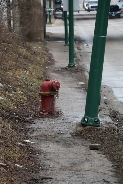
Crumbling infrastructure is a challenge along the corridor.

CDOT, is responsible for public way infrastructure, including planning, design, construction, maintenance, and management. Learn more >

DPD, is the principal planning agency for the City of Chicago and promotes the comprehensive growth and sustainability of the City and its neighborhoods. Learn more >

If you have additional comments or questions, share them with the planning team in the form below!
Send us your comments or questions!
Your message will be sent to a member of the planning team - we appreciate your input!